2015 Weather Thread
under a meter to 145cm in Australia is a huge difference!
I’m guessin that he’s talkin depth at Spencer’s Creek?????
Thats what i think too!
either way its a big difference in guesses!
It’s nearly at 145cm at last reading though isn’t it?????
Exactly!
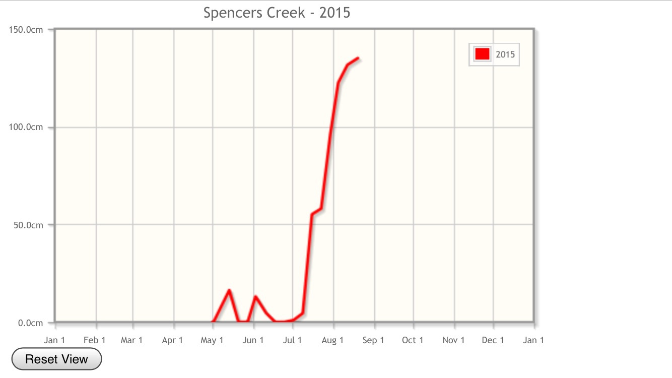
Last Thursday was 145cm, after the r#!n damage this past weekend Brenno is saying it will be a lot less this week and also by the 1 Sept.
I am disagreeing - i don’t see us losing 45cm between last Thursday and next tuesday (or the Thursday measurement.
Snow pack is gunna take a big hit by the end of winter. Id say base will be back under 1m by sept 1.
I thought you were referrin to his last post that was after yours, and before your post on top of this page!!!!!
the charts have been bouncing around a lot the past few days. I woudnt be expecting dry pow. there is no feed of cold antarctic air with these fronts.
wet snow is better than rain, but spring is fast approaching and it looks like the base has reached
its peak. there looks to have been a lot of base melt the last week, so looks like that will be replaced.
I reckon thurs measurement will be about 145 at best. hope im wrong !
under a meter to 145cm in Australia is a huge difference!
And after this pukage were gettin right now, I too reckon the level has far from finished risin!!!!!
Well 30cm overnight with more to come.
Just hop we get the promised 30cm on Thursday!
Okay - direct quote from Donza for Hotham on Thursday.
looks fantastic for some cold snow from the south Thursday lunch on and cold and snowy on Friday
when I made that call a few days ago, it was based on the chart run from the day before. everyone
was caught out by this event. thankfully cold air pushed up into the front and that was the difference
between 30cm of snow or 30mm of rain. when I made the call about the pack being decimated, that was based on the ECL hammering the resorts. look what happened from fri to sunday. there was significant snow loss. my comment was that last week spencers creek was 135cm. I reckon they lost 20-30 between then and Monday morn. with what was looking like about 45 out of this storm plus settling of the pack that’s where I got a figure of 145. but going by the falls it will exceed that and that’s a good thing! next wed/thurs is looking good for some cold air and good falls. a few degrees in temp difference is sending us from a 1m pack at start of sept to prob 190 instead. it will set it up for a good spring. hail the snow gods!
one of the keys to seeing if its a truly good year is to look at the snow depths at deep creek(1620m)
which is at a lower elevation than spencers creek(1820m). take the last 2 years for example. 2013 is regarded as a shit year by anyone who skis a lot. its peak was 185cm, which you would think is a good year. deep creek peaked at 72cm. last year the peak was 168cm. it was regarded as a really good year even though it barely snowed in august. deep creek was 119cm. what this shows is that the falls last year were heavy down to low levels, providing an overall thicker base at all the resorts and good coverage.
2013 had good falls but at higher elevations. end result is places like Selwyn, smigs, lower half of thredders exit early come spring, and really only just have ordinary base depth, not the rubbish the resorts blurt out! last year was a bigger base at those resorts so those lower elevation spots lasted an extra week or 2.
this year so far has been 2013ish depth wise, but the last 24hrs will change that abit, although I suspect
deep creek , currently sitting at 56cm, wont rise to much as it would of been belted on the weekend. smigs looked on the way out by sunday arvo, which is at deep creeks elevation, but these storms should give those lower areas an extra week or 2, and keep more lifts open overall deep into sept.
fingers crossed !
when I made that call a few days ago, it was based on the chart run from the day before. everyone was caught out by this event.
yep everyone was caught out by these storms.
BUT I still claim that we get a good spring storm every year.
And that your call for a <1m base was too early.
when I made that call a few days ago, it was based on the chart run from the day before. everyone was caught out by this event.
yep everyone was caught out by these storms.
BUT I still claim that we get a good spring storm every year.
And that your call for a <1m base was too early.
not really, if that was rain, not snow, it would be back around 1m mark now.
a few degrees turnaround in temp was all the difference!
sure theres storms in spring, but with longer warmer days, the pack quickly
starts to melt again. unless this sept gets weekly storms, the end of next week
will most likely hail the peak in snow depth. mid next week is looking good
for a solid dump too!
Sorry we have to agree to disagree!
e.g the claim that by next week we will have half the snow pack of tomorrow’s measure…
I think you people should stop arguing about the weather and get out there and ride it.
