2016 Weather thread
This is looking super interesting.
Is is a 192 hr projection of EC showing some really nice thickness (friday 10pm).
these models aren’t for the public…so you don’t get this much detail usually
This is close up.

This is looking super interesting.
Is is a 192 hr projection of EC showing some really nice thickness (friday 10pm).
these models aren’t for the public…so you don’t get this much detail usually
Can you please elobarate on why this is interesting?
Also I really struggle with the x hours out (i am assuming that is 192 ho9urs out about?
Can we have some laymens terms please!
This is looking super interesting.
Is is a 192 hr projection of EC showing some really nice thickness (friday 10pm).
these models aren’t for the public…so you don’t get this much detail usuallyCan you please elobarate on why this is interesting?
Also I really struggle with the x hours out (i am assuming that is 192 ho9urs out about?
Can we have some laymens terms please!
Sorry…..
Thickness… the distance between the air at 500hpa and the air at 1000hpa… the shorter the distance the colder the air (the magic 540 line)
EC models don’t have thickness charts available to the public. These are the professional charts.
They show more detail. We usually rely on GFS charts for thickness (like the wunder map ones posted above). EC is a much much better model
192 hrs… yeah 192 hrs from when the model was run.. the models are run at 10am and 10pm sydney time. However it takes hours for the graphical pictures etc to be posted .
Tues and thursday are looking pretty good!
Long term around 25th there could be something going by the LWT. Then possibly 10th july.
Yeah it does.
Indeed… few nodes circling the southern lats at the moment… which is good.
As someone who is at Falls Creek, this weekend has been FKN terrible.
Has not stopped raining.
Need Thursday to turn it on to save opening weekend :(
does the frog even look at the charts on snowatch?? his report today says no snow for a week and barely cold enough for any snowmaking. i n fact hes a myth. years ago when he started out he was good. now he gets traffic = advertising $ he dont give a toss…..weatherzone are saying from tues night onwards snowmaking is possible. looking at the charts theres plenty of cold air coming. and I still reckon Thursday is looking good despite the call being either no snow or 2cm.
Yeah he sold out badly. Mountainwatch is much better these days, just look more into his actual forecasts and less into the weather bar at the top.
Currently Falls looks to get a bit of slushy shite tomorrow and then maybe a half decent Saturday night if my predictions are correct.
Saturday at 5pm looks to be my pick of the crop for a decent snowfall that will really help us out.
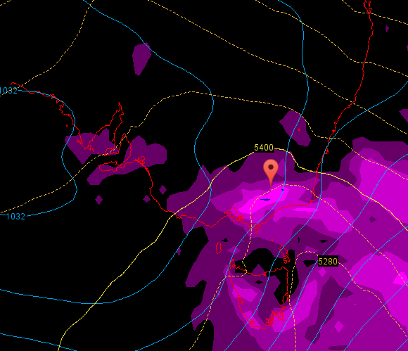
Picture is bottom right of Aus obviously and the 5400 line being above Falls with brighter purple means we will get some precip.
ECL looks likely to wash out the resorts Monday but the LWT is bringing the goods in 8-10 days!
Looking like rain till the end of the month. Decent chance to open the resort on the 29th I say.
Yeah - whilst part of me is happy that we don’t have an epic start (i have enough going on in sydney right now) i am devo for the rest of the season.
Thursday on looks promising…